Splashmaps
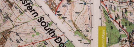
SplashMaps were on show at the Outdoors Show in London but we completely missed them — we've since read a couple of articles on the SplashMap and thought, how could we have missed that? However carefully you walk round an exhibition centre, you'll always miss something. SplashMaps is a great concept: their idea is that traditional maps aren't designed for the outdoors — a paper map gets dirty, ripped and wet, while a plastic-coated map is bulky and difficult to carry.
Enter the SplashMap — a fabric map. This makes it lightweight and durable, easy to carry or wear while walking, biking or doing a range of outdoor activities. The creators have even been seen wearing it as a bandana while mountain biking.
SplashMaps used Kickstarter, the crowdsourced funding site, to gain enough funding to attend the Outdoors Show and produce their first map.
The Maps
You won't recognise these as traditional 1:25,000 or 1:50,000 maps. SplashMaps combine Ordnance Survey data and OpenStreetMap data to create a map specialised to the needs of an outdoor adventurer. The scale is actually 1:40,000 — a scale they describe as the sweet spot between having enough detail to know where you are, while being a large enough scale that you can cover a decent distance with just the one map.
At launch, SplashMaps had just two maps available to buy directly from their own website — the Western South Downs and the New Forest — with plans to expand the range to the National Parks of Great Britain, site-centred maps, and maps of other parts of the world.
Would you switch to a fabric map?
Would you find a fabric map an essential, or do you find a traditional paper or laminated map just fine and see no need to change? It's a genuinely different way of thinking about a map — closer to a piece of kit than a document — and worth a look if you're tired of paper maps disintegrating in the rain.